Bring the essence of the United Kingdom to your PowerPoint presentations with our expertly designed map templates. From the bustling streets of London to the rugged Scottish Highlands, these maps provide a comprehensive view that`s ideal for professionals in finance, tourism, and policy-making.
Our templates stand out with their vector-based construction, ensuring scalability without quality loss. Easily highlight devolved regions like Wales or Northern Ireland for targeted discussions on governance or market shares. Whether crafting a sales forecast or a cultural overview, these tools simplify complex layouts into intuitive visuals.
Targeted at executives and teachers alike, our UK maps enhance clarity and engagement. Dive into our collection and select the design that best suits your narrative - your audience will notice the professional touch.


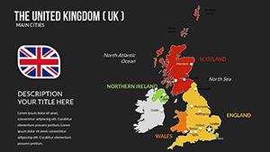
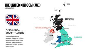

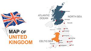
The United Kingdom`s intricate geography demands maps that capture its nuances, and our PowerPoint templates deliver just that. Featuring detailed outlines of England, Scotland, Wales, and Northern Ireland, these designs support everything from Brexit impact analyses to heritage tourism promotions. Professionals appreciate the ability to layer economic indicators over major cities like Manchester or Edinburgh, turning static slides into interactive stories.
In contrast to basic built-in tools, our maps include pre-annotated points of interest and customizable legends, saving valuable design time. Educators find them invaluable for geography classes, illustrating the UK`s role in global trade routes with animated paths.
These features make our templates a step above generic options, fostering deeper audience connections.
Business developers use UK maps to delineate sales territories, overlaying performance metrics for boardroom clarity. In education, animate historical events like the Industrial Revolution across regions, engaging students with visual timelines. Marketing teams craft campaigns highlighting local festivals in Cornwall or tech hubs in Cambridge, driving brand relevance.
A real-world application: A real estate firm mapped property trends across the Midlands, securing investor buy-in through vivid projections. To maximize impact, pair maps with bullet-point summaries and ensure color schemes evoke national pride - think deep blues and reds.
Integrate these strategies to make your presentations not just informative, but unforgettable.
Complement your UK PowerPoint maps with our timeline or flowchart templates for holistic storytelling. Download now and witness how geographic precision amplifies your message.
Addressing common queries to help you get started - explore our library for even more inspiration.
Copyright © 2009-2026 ImagineLayout All rights reserved.