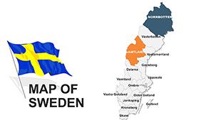
Sweden maps tailored for PowerPoint empower you to highlight geographic specifics with elegance and ease. These templates delineate counties, waterways, and urban centers, ideal for economic analyses, heritage talks, or logistics overviews. Crafted for managers, historians, and planners, they deliver accuracy wrapped in visual charm.
Visualize your data flowing across Sweden`s terrain, from Baltic shores to mountain ranges, engaging viewers with purposeful precision. Fully vectorized for crispness, our maps integrate icons and annotations that enhance without cluttering. Perfect for transforming raw stats into persuasive narratives that drive decisions.
Scan our Sweden map selection and pinpoint the layout that suits your vision. Whether for quick briefs or detailed exposés, they`re ready to refine your PowerPoint experience. Launch into creation today and chart your course effectively.


In PowerPoint, Sweden maps anchor narratives around place-based themes, clarifying distributions and movements for better retention. They`re particularly potent in sales demos or policy rundowns, where localized visuals underscore relevance, potentially lifting persuasion rates significantly.
Executives map investment hotspots, coloring districts by ROI. Schools employ them for folklore lessons, tracing tales across landscapes. Logistics experts plot distribution networks, with arrows linking hubs like Malmö to Luleå.
PowerPoint`s morph tool pairs beautifully, animating shifts between map states fluidly.
Basic PowerPoint inserts pale against our detailed Sweden templates, which boast layered counties and scalable features absent in defaults. Editing is intuitive - no redraws needed - saving time over third-party imports that disrupt formatting.
They outshine generics by embedding Swedish specifics, like archipelago details, for authentic depth. High-fidelity renders suit widescreen or print, maintaining integrity across outputs.
These habits yield maps that mesmerize and inform.
Push boundaries by merging Sweden maps with calendars for event planning across seasons, or with demographics for social trend visuals. A real estate agency spotlighted property booms using gradient fills on urban maps, accelerating client conversions.
Try sectional zooms for deep dives into areas like Skåne, or global insets for export contexts. Our range from stark monochromes to textured terrains supports varied vibes.
Pick one and populate it with your particulars.
Harmony rules: Align with slide grids for tidy placements, using Sweden`s cool tones for serenity. Leverage SmartArt for auto-adjusting labels, easing updates. Accessibility via ARIA tags describes map intents for all users.
Sync with themes for cohesive decks, refreshing data quarterly for currency.
Elevate your geographic game. Secure Sweden map templates immediately and steer presentations masterfully.
Copyright © 2009-2026 ImagineLayout All rights reserved.