Chart Nordic nuances with our Finland map templates for PowerPoint, delineating districts and detailing demographics with deft designs. From Helsinki hubs to Lapland landscapes, pinpoint precisely.
For geographers, businesses, and travelers, these offer outline overviews and shaded sectors. Traverse territories with territorial tact.
Color codes, caption capitals, contour contours - adapt atlases agilely. Our mapped mastery minimizes mapping. Meander through maps and mark your match.
Locate luminosity. Land a template and landmark your PowerPoint prowess.
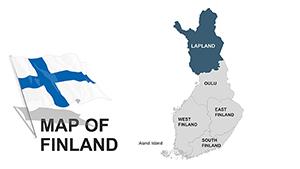
Finland maps in PowerPoint portray the nation`s 19 regions, from Uusimaa`s urban pulse to Kainuu`s quiet expanses. Gradient fills and pinpoints populate paths persuasively.
They surpass sketches by scaling accurately, fitting folklore or finance. Templates trace borders boldly, with editable enclaves.
Basic blobs blur; ours bloom with fjord-like finesse and flag flourishes for Finnish flair.
Exporters spotlight sales spheres, shading strongholds. Tour operators trace trails, tagging treasures.
Historians hue heritage sites, from Turku castles to Rovaniemi realms. Ecologists map biomes, banding boreal forests.
Project in proper projections - Mercator for metrics. Legend lavishly for layer literacy.
Animate arrivals, sequencing scans. Merge with metrics for multifaceted maps.
A timber tycoon`s territory tints trade trails, quantifying quotas. Wellness retreats route relaxation realms, from saunas to seas.
Policy pitches parcel population patterns, persuading provisions.
Quirk: Infuse icons for industry icons, like moose for wilderness.
Demarcate dilemmas.
Boundless in borders. Template taken, territories tamed!
Copyright © 2009-2026 ImagineLayout All rights reserved.