Chart your course through Brazil`s diverse terrain with our specialized PowerPoint maps templates, ideal for geographers, marketers, and international business pros. These editable outlines capture the country`s 26 states and federal district, from Amazon rainforests to urban metropolises, in crisp, vector-based designs.
Highlight trade routes, demographic shifts, or tourism hotspots with color-coded regions and pinpoint markers. Fully customizable in Microsoft PowerPoint, add data overlays, animations for region reveals, or integrate stats via linked charts - turning static maps into dynamic stories.
Suited for reports, pitches, or educational content, our templates blend accuracy with aesthetic appeal. Ensure your audience connects with Brazil`s vibrancy through visuals that inform and inspire. Explore the collection and map your success today.


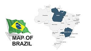
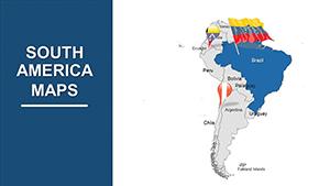
Brazil`s vast geography demands precise representation, and our templates deliver with layered states that isolate for focus - e.g., zoom on São Paulo`s economy without losing national context. Marketers use them to plot market penetration, while educators trace historical migrations.
PowerPoint`s grouping tools shine here, allowing drag-resizing without distortion, and shadow effects add terrain-like depth.
From boardrooms to classrooms, they ground global discussions in local detail.
Free online maps often suffer low resolution or outdated boundaries; ours update to current delineations with high-fidelity paths that scale flawlessly. Defaults lack editable text boxes - we include them for seamless labeling of capitals and waterways.
Bonus: Integrated legends auto-generate from color schemes, streamlining setup.
Accuracy: Based on official GIS data. Interactivity: Hyperlink regions to detail slides. Customization: Texture fills for thematic variety.
Start with a blank canvas slide for context, then animate state highlights sequentially. Use consistent scales for comparisons, and incorporate legends early. For engagement, add pop-up facts on hover.
Clever approach: Blend satellite imagery backgrounds for realism, cropped to fit. Verify projections (Mercator for area accuracy) to avoid distortions.
Plot your path forward? Check out Brazil PowerPoint maps templates and download to visualize your vision.
Brazil`s story unfolds on these maps - use them to narrate yours with authority and allure.
Copyright © 2009-2026 ImagineLayout All rights reserved.