Baltic States PowerPoint Maps

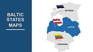
Navigate the geopolitically charged Baltic region with confidence using our PowerPoint map templates. Covering Estonia, Latvia, and Lithuania, these assets are indispensable for strategists mapping security perimeters or historians charting independence arcs.

Built for PowerPoint`s robust ecosystem, the maps feature resizable elements and smart art compatibility, ideal for layering defense stats or cultural metrics. From Vilnius`s old town to Daugavpils`s heritage, bring subtle details to life without complexity.

Suited for military planners, academics, and investors, our designs promote clarity amid intricacy. Review our Baltic States PowerPoint maps and select the one that fortifies your argument - precision awaits.


View by: Last Added | Most Popular
  • like 4
    (462)
    Norway PowerPoint Maps Template: Download PPT
    ID: #PM00191
    $55.00
  • like 3
    (958)
    Netherlands PowerPoint Maps - Download Template
    ID: #PM00190
    $50.00
  • like 3
    (1133)
    Editable EU Maps PowerPoint Template: 61 Slides
    ID: #PM00175
    $58.00
  • like 4
    (1085)
    EU Countries PowerPoint Maps Template - High-Quality PPT
    ID: #PM00174
    $35.00
  • like 4
    (826)
    EU PowerPoint Maps Template - Customizable & Detailed
    ID: #PM00173
    $35.00
  • like 5
    (681)
    World Country Maps PowerPoint Template: Unlock Global Insights
    ID: #PM00169
    $26.00
  • like 3
    (1085)
    Custom World Maps PowerPoint Template - Get Now
    ID: #PM00167
    $26.00
  • like 4
    (384)
    World Countries PowerPoint Maps: Chart the Globe with 65 Editable Masterpieces
    ID: #PM00061
    $35.00
  • like 3
    (665)
    Weather and Climate Maps for PowerPoint: Forecast Your Message with Precision
    ID: #PM00060
    $20.00
  • like 3
    (590)
    Editable Baltic States PowerPoint Maps Template: Visualize Your Vision
    ID: #PM00056
    $45.00
  • like 4
    (545)
    Baltic States PowerPoint Map: Weave Europe's Northern Tapestry
    ID: #PM00005
    $38.00
  • like 3
    (228)
    World Maps PPT Template for Global Insights
    ID: #PM00002
    $38.00


Strategic Edge from Baltic States PowerPoint Maps

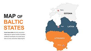
In presentations demanding accuracy, our Baltic maps provide the foundation. Outlining shared coastlines and borders, they excel in depicting hybrid threats or growth sectors. Far from rudimentary drawings, these incorporate grid references for pinpoint accuracy.

Security analysts highlight NATO flanks, educators trace Soviet legacies. PowerPoint advantages include morph transitions for evolving scenarios, absent in simpler tools.

Distinctive Design Elements

  • Border Fidelity: Exact reproductions for trustworthy depictions.
  • Modular Builds: Separate slides for country spotlights.
  • Metadata Tags: For quick searches within large decks.

Such refinements elevate standard visuals to professional standards.

Real-World Scenarios and Wins

Think tanks use them to model energy dependencies, swaying policy debates. Lecture halls benefit from phased reveals of EU integrations, aiding retention. Investment pitches map tech startups in Tartu, attracting capital.

Success story: A consultancy visualized shipping lanes, clinching a major contract. Key tactic: Embed hyperlinks to sources, bolstering credibility.

Optimization Strategies

  1. Group related elements for uniform animations.
  2. Contrast land and sea for immediate orientation.
  3. Archive variants for iterative refinements.

These practices ensure impactful, repeatable results.

Fortify Your Presentation Arsenal

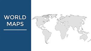
Link with our global conflict templates for context. Grab yours today and strategize smarter.

Frequently Asked Questions

Essential clarifications - empower your work with our curated maps.