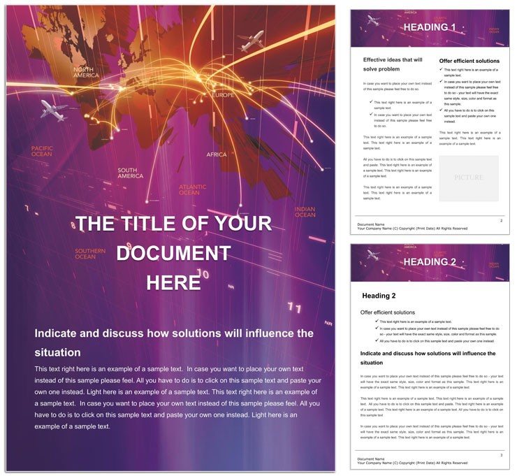
Imagine charting the invisible threads of global air travel with precision and flair - routes that weave across continents, hubs pulsing with activity, all captured in a document that doesn't just inform but inspires. The 3D Map Flights Word template is your gateway to such visualizations, tailored for aviation professionals, logistics coordinators, and travel planners who need to convey complex flight networks without the clutter of generic spreadsheets. This editable Word document packs vector-based 3D maps that twist and turn like real-world flight paths, making your reports on airline operations, cargo scheduling, or passenger flows stand out in boardrooms or regulatory filings.
At its core, this template transforms dry data into dynamic narratives. Whether you're documenting seasonal route expansions for a major carrier or outlining emergency evacuation plans for an airport authority, the pre-built 3D elements let you layer in specifics like altitude markers, time zones, and weather overlays with ease. No more wrestling with clunky drawing tools in Word - everything here is scalable, color-shiftable, and ready to adapt to your brand's palette. Priced at just $22, it's an investment that pays off in hours saved and impressions made, turning what could be a tedious task into a showcase of strategic insight.
Unlocking the Skies: Key Features of the 3D Map Flights Template
Dive deeper into what makes this template a must-have for anyone navigating the skies on paper. Starting with its foundation in A4 format - standard for professional documents worldwide, yet flexible enough to resize for letter or custom specs - the design ensures compatibility across teams and printers. The vector shapes are the real stars: icons for planes, airports, and control towers that you can resize without losing crispness, recolor to match airline liveries, or even reshape for unique emphases like drone corridors.
- Interactive 3D Mapping Elements: Built-in paths that simulate flight trajectories, complete with gradient shading for depth and shadow effects for realism. Drop in your data via simple tables, and watch the maps auto-populate.
- Wizard-Guided Customization: A step-by-step slide wizard walks you through inserting flight schedules, passenger stats, or fuel efficiency metrics, ensuring even non-designers produce pro-level outputs.
- Simple Yet Sophisticated Layout: Clean grids and timelines integrate seamlessly with the maps, avoiding overload while highlighting key intersections like peak traffic zones.
These features aren't just bells and whistles; they're practical tools honed for the fast-paced world of aviation. Picture a logistics manager at a freight airline using the timeline to forecast delays from volcanic ash clouds - the 3D arcs visually connect cause and effect, making arguments for rerouting crystal clear.
Step-by-Step: Building Your First Flight Map
- Download and Open: Grab the .dotx file and launch it in Word 2016 or later - full backward compatibility means your older setups won't skip a beat.
- Input Data: Head to the data sheet tab, paste in CSV exports from your flight management software, and hit refresh. Vectors update instantly, pulling in real-time elements like gate assignments.
- Layer and Label: Add text boxes for annotations - think "Hub Delay: 15%" - and toggle layers to hide/show details for different audiences, from executives to ground crew.
- Export and Share: Save as PDF for print-ready reports or embed in emails; the high-res JPG previews let you thumbnail-test before finalizing.
This workflow cuts prep time dramatically, letting you focus on analysis rather than aesthetics. Compared to starting from scratch in Word's basic shapes, where alignments drift and colors clash, this template's locked-in grid keeps everything aligned, even as you iterate.
Real-World Routes: Use Cases That Take Off
The beauty of the 3D Map Flights template lies in its versatility across aviation's broad landscape. For airline executives plotting network expansions, the curved paths illustrate market gaps - say, underserved routes between emerging economies - far more persuasively than flat tables. A case in point: urban air mobility firms, like those pioneering eVTOL services, use similar 3D visuals to pitch vertiport placements to city planners, emphasizing safety corridors over congested airspace.
In operations, it's a lifeline for shift handovers. Ground handlers can map out incoming flights with color-coded urgency levels, integrating weather radar snippets for proactive staffing. And for sustainability reports? Overlay carbon footprints along routes, using the template's eco-themed icons to underscore green initiatives without preaching.
Educators in aviation training programs find it invaluable too. Instructors craft lesson plans on air traffic control, embedding interactive maps that students manipulate to simulate scenarios like mid-air merges. It's hands-on learning that sticks, bridging theory and practice in a single document.
Tailoring for Your Fleet: Customization Tips
To make it yours, start with the color scheme - swap blues for your carrier's signature reds, ensuring accessibility with high-contrast modes for color-blind reviewers. Incorporate branded elements like logos into airport icons, and use the wizard to auto-generate legends for multi-leg journeys. For international docs, toggle to metric units seamlessly, keeping global teams aligned.
A pro tip: Pair it with Word's mail merge for personalized passenger itineraries, where each map highlights custom detours. This level of detail turns standard reports into client-facing assets, boosting retention in competitive travel sectors.
From Blueprint to Boardroom: Why This Template Wins
What sets the 3D Map Flights Word template apart from free alternatives? It's the thoughtful integration of form and function - vectors that scale without pixelation, layouts that flow on any device, and a simplicity that invites collaboration. No steep learning curve; just open, edit, and impress.
Download the 3D Map Flights Word template today for $22 and chart your course to clearer, more compelling aviation documents. Your routes deserve visuals this vivid.
Frequently Asked Questions
What file formats are included with the 3D Map Flights Word template?
The template comes in .dot and .dotx formats for full Word compatibility, plus high-res JPG previews for quick sharing.
Can I resize the maps for different document sizes?
Yes, the vector-based design allows easy resizing from A4 to custom formats without quality loss.
Is the template compatible with older versions of Microsoft Word?
It works seamlessly with Word 2016 and later, with most features supported in 2013.
How do I add my own flight data to the maps?
Use the built-in data table to input coordinates and schedules; the wizard auto-renders the 3D paths.
Are there icons for specific aviation elements like drones?
The set includes planes, helicopters, and airports; for drones, duplicate and reshape existing vectors easily.