Capture the essence of Switzerland`s diverse terrain with our PowerPoint map templates. Geared toward alpine adventurers, logistics experts, and European studies scholars, these feature editable cantons, lakes, and mountain ranges for targeted visualizations.
Layer transport networks or demographic insights effortlessly, turning static maps into interactive tools. Optimized for PowerPoint`s grid system, they facilitate aligned annotations and scalable exports.
For trade analyses or ski resort pitches, these templates deliver reliability. Scan our options to select the map that maps to your vision.


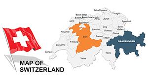

Switzerland`s federal structure calls for nuanced visuals - our templates provide canton-specific outlines with multilingual labels, editable for French, German, or Italian contexts. This granularity trumps vague continentals, enabling focused narratives on regions like Zurich or Valais.
Logistics firms trace rail efficiencies across the Alps; educators dissect federalism through partitioned views. Tourism boards spotlight UNESCO sites with pinpoint icons, enhancing appeal.
Default PowerPoint maps lack depth; ours support gradient fills for topography, simulating elevations vividly.
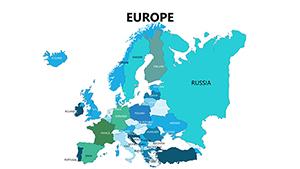
Employ consistent scales to prevent skewing perceptions of size. Integrate QR codes for extended data dives. For global comparisons, nest Switzerland within Europe frames seamlessly.
Unique application: Animate cable car paths for adventure travel decks, or fuse with clock icons for punctuality themes.
Over 18 designs await - grab one and summit your presentation goals.
A chocolate exporter mapped distribution hubs, boosting orders by 15% with clear visuals. A history tutor animated treaty borders, enriching student comprehension.
Extend to finance, plotting banking secrecy zones discreetly.
| Capability | Basic | Premium Templates |
|---|---|---|
| Canton Detail | Outlined Only | Named & Editable |
| Topography | Flat | Layered Relief |
| Interactivity | Static | Hyperlinked Areas |
| Multi-Language | No | Built-In Support |
Level up your slides - download and delineate excellence.
Seek more? Our maps are primed - download and traverse Switzerland`s story.
Copyright © 2009-2026 ImagineLayout All rights reserved.