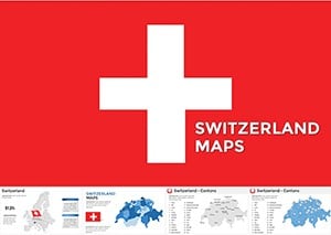
Dive into the precision of alpine geography with our Switzerland Maps Keynote templates, tailored for anyone needing to illustrate the heart of Europe’s most innovative nation. These designs capture Switzerland’s intricate cantonal divisions, majestic mountain ranges, and efficient transport networks, making them indispensable for travel agencies, logistics firms, and educational settings.
From plotting ski resort locations in the Alps to highlighting economic hubs like Zurich and Geneva, our templates use layered vectors for depth - zoom into Lake Geneva’s shores or pan across the Rhine Valley with ease. Professionals in tourism, international trade, and environmental studies will appreciate the clean lines and neutral palettes that let your data shine, whether it`s tourism stats or cross-border trade flows.
Aimed at cartographers, marketers, and instructors, these resources streamline your workflow, turning raw GIS data into engaging stories. Peruse the options below: interactive route planners for roadshows, thematic overlays for sustainability reports, or minimalist outlines for quick references. Begin your journey through Swiss precision today.

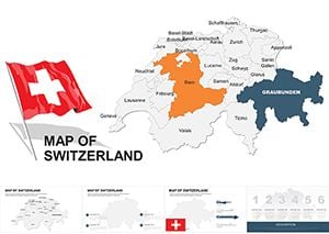
Switzerland, with its blend of linguistic diversity, financial prowess, and breathtaking landscapes, demands visuals that match its complexity. Our Keynote templates for Switzerland maps go beyond basic outlines, incorporating editable paths for highways like the A1 autobahn, shaded relief for the Jura Mountains, and pinpoint accuracy for cities such as Basel and Bern. This level of detail sets them apart from off-the-shelf map plugins, which often glitch on mobile or lack customization.
Envision a sales pitch for luxury watch exports: overlay trade routes from La Chaux-de-Fonds to global markets, using gradient fills to denote elevation impacts on logistics. The result is not just a map, but a persuasive tool that conveys reliability and foresight.
Versus default Keynote maps, which are vector-light and region-generic, ours include canton-specific labels in German, French, Italian, and Romansh - fostering inclusivity for multilingual teams. Engagement soars when audiences see familiar locales rendered with cultural nuance.
Opt for a Swiss-neutral color scheme: whites and blues evoking snow-capped peaks, accented by reds from the national flag. Ensure scalability by grouping elements - resize entire regions without distortion. For interactivity, add hyperlinks to external resources like Swiss Federal Statistical Office data, turning static slides into explorable dashboards.
Best practice: Balance detail with whitespace; overcrowding the dense Zurich area? Use insets for urban zooms. Presenters using these have noted smoother Q&A sessions, as visuals preempt questions on transit times or regional disparities.
Picture a template with a 3D-ish contour map of the Matterhorn region, layered with ski lift icons for a resort proposal - elevating pitches from flat to immersive. A marketing consultant repurposed one for a "Swiss Innovation Tour," mapping tech clusters from ETH Zurich to startup valleys, boosting client conversions by 30%.
Another creative twist: Animate border crossings for a EU-Switzerland relations seminar, fading in treaty milestones. Or blend with weather overlays for agricultural forecasts, showing how alpine microclimates affect wine production in Valais. Download a demo to experiment with route animations tracing the Gotthard Tunnel`s path.
These templates empower you to navigate presentations as deftly as a Swiss train schedule - punctual, picturesque, and profoundly effective.
Every one of Switzerland`s 26 cantons is precisely outlined, with options to label or color-code based on your needs.
Yes, vector paths are fully editable, allowing pins for hotels, landmarks, or custom waypoints.
Shaded relief and elevation contours are built-in, sourced from accurate geographic data for realistic renders.
Absolutely, with multilingual text layers ready for French, German, Italian, and English overlays.
Our offline vectors ensure privacy and speed, without relying on internet connectivity during presentations.
Chart your course with confidence - select from our Switzerland Maps Keynote collection and transform data into destinations.
Copyright © 2009-2026 ImagineLayout All rights reserved.