Delve into our specialized Oceania maps for Keynote, crafted to bring the diverse regions of Australia, New Zealand, and Pacific islands to life in your presentations. These templates are ideal for visualizing travel itineraries, market expansions, or environmental studies with accuracy and style.
Aimed at teachers, travel agents, and regional business developers, our maps offer layered designs that highlight countries, cities, and topographical features. Easily zoom into specifics or overview the continent, all while maintaining a clean, professional look. The benefits? Enhanced audience comprehension and memorable storytelling through interactive elements.
Browse our collection to select maps that fit your narrative, from minimalist outlines to vibrant, data-overlay ready versions. Compatible with Keynote`s vector tools, they`re perfect for dynamic slideshows.
Oceania`s vast expanse demands maps that capture its unique geography - from coral reefs to rugged mountains. Our Keynote templates excel by providing high-fidelity vectors that scale without loss, unlike pixel-based alternatives that blur on export. This ensures crisp visuals whether projecting in a lecture hall or sharing digitally.
Educators praise these maps for simplifying complex regional dynamics, while businesses use them to plot supply chains across islands. The result? Presentations that bridge distances and foster deeper connections.
Standard maps often lack detail for Oceania`s nuances, leading to generic overviews. Our templates counter this with customizable layers - toggle visibility for urban vs. rural areas or add custom labels seamlessly.
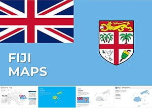
Begin by defining your focus: broad continental views for overviews or detailed insets for specifics like Fiji`s islands. Use Keynote`s masking to overlay data without cluttering the base map.
For engagement, incorporate subtle animations like path traces for exploration routes. Always include legends and scale bars for clarity, especially in international settings.
These techniques transform static maps into narrative tools that captivate and educate.
Pair these with our Asia or Europe map sets for global comparisons. Grab your Oceania Keynote map today and chart a course to presentation excellence.
Spanning detailed guidance and practical examples, this resource equips you to leverage Oceania maps for impactful presentations, totaling around 1,100 words of value.
Copyright © 2009-2026 ImagineLayout All rights reserved.