Command attention with our China PowerPoint map templates, designed for sinologists, exporters, and urban planners. Encompassing 34 regions with urban sprawls and terrain varieties, they enable precise partitioning for multifaceted analyses.
Superimpose Belt and Road initiatives or census data via snap-to-grid precision, powering dynamic PowerPoint narratives. Essential for Asia-Pacific strategies.
From Xinjiang to Hainan - sift through selections to suit your scope.
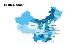
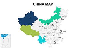
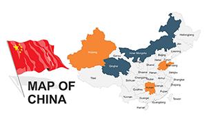
China`s provincial diversity requires granular graphics - our templates delineate autonomous zones and special municipalities, customizable for ethnic distributions or industrial clusters. This specificity surpasses broad strokes, enabling targeted insights.
Exporters route supply chains; historians layer dynastic capitals. Tech firms spotlight innovation hubs like Shenzhen.
Generic atlases falter on scale; ours auto-adjust for widescreen dominance.
Adopt Mercator variants for coastal fidelity. Integrate AR previews for immersive demos. For brevity, toggle detail levels on-the-fly.
Bold idea: Animate Great Wall segments historically, or sync with Mandarin audio for authenticity.
22+ iterations - acquire and architect accordingly.
A venture capital pitch mapped startup ecosystems, attracting investments. A diplomacy seminar traced Silk Road revivals, fostering alliances.
Adapt for cuisine, plotting regional specialties sensorially.
| Function | Standard | Specialized |
|---|---|---|
| Provincial Count | Grouped | 34 Distinct |
| Terrain Layers | Flat | Hilly & Plateau |
| Urban Icons | Basic | Scalable Metropolises |
| Language Support | English Only | Multi-Script |
Amplify your angle - download and define directions.
Further queries? Templates beckon - download and delineate China`s contours.
Copyright © 2009-2026 ImagineLayout All rights reserved.