Unveil the vibrancy of Central America through our PowerPoint map templates, suited for historians, trade specialists, and environmental advocates. These encompass seven nations with editable coastlines, volcanoes, and trade routes for layered storytelling.
Infuse migration patterns or biodiversity hotspots with minimal tweaks, leveraging PowerPoint`s alignment tools for polished outputs. From isthmus overviews to country spotlights, they adapt fluidly.
Perfect for global affairs talks or adventure planning - review our lineup to chart your path.
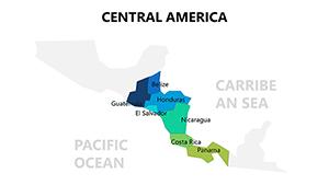
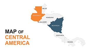

The isthmus`s strategic bridge role shines in our templates, with canal highlights and fault line traces for geological flair. Editable polygons allow country-specific styling, surpassing blurry scans in fidelity.
Trade analysts diagram export flows; conservationists overlay protected reserves. Schools animate Panama Canal history for engaging recaps.
Unlike stock images, ours embed data tables for metric syncing.
Scale uniformly to reflect true proportions. Embed audio clips for indigenous languages. For comparisons, juxtapose with North America frames.
Creative: Animate hurricane paths for resilience workshops, or link to live cams for real-time eco-updates.
25+ styles available - download and connect the dots.
A logistics conference mapped shipping lanes, streamlining discussions. An NGO visualized aid distribution, raising funds efficiently.
Apply to archaeology, plotting Mayan sites temporally.
| Tool | Conventional | Our Versions |
|---|---|---|
| Country Borders | Rigid | Flexible Paths |
| Natural Features | Omitted | Volcano & River Traces |
| Data Integration | Manual | Table-Linked |
| Export Versatility | Basic | Animated GIFs |
Elevate your regional focus - select and deploy.
More insights? Templates ready - download and journey through.
Copyright © 2009-2026 ImagineLayout All rights reserved.