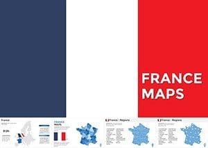
Unlock the geography of France with our versatile France map Keynote templates. Designed for presentations on travel itineraries, regional economics, or historical events, these maps provide a clear canvas for your insights.
Teachers, tour operators, and market researchers will love the region-highlighting features, from Provence lavender fields to Paris urban hubs. Keynote`s vector precision allows effortless zooming into departments or overlaying stats like population densities.
Visualize wine regions with color gradients or plot tourist routes with animated paths - these templates make France`s diverse landscapes come alive. Whether charting sales territories or cultural landmarks, they ensure your audience grasps spatial stories at a glance.
Navigate this category to find maps that blend accuracy with artistry. Start customizing your French narrative today.
France`s rich tapestry demands precise visuals, and our maps deliver across sectors. In education, outline the Loire Valley for history classes, with pop-up labels on chateaus. Travel agencies craft itineraries, shading routes from Normandy beaches to Alpine peaks.
Business analysts overlay revenue heatmaps on regions, spotting trends in luxury goods from Lyon. Journalists mapping election results use choropleth designs for voter distributions. Interactive elements let viewers tap regions for details, enhancing engagement.
For a road trip deck, animate connecting lines between cities, timed to narrative pacing for immersive storytelling.
Highlight GDP variances with gradient fills, from industrial north to agrarian south, supporting data-driven arguments.
Stock Keynote maps often lack departmental boundaries or scalability, leading to pixelation on zoom. Our templates feature layered SVGs for independent editing - color Alsace without affecting Brittany - and include legends auto-updating with changes.
Unlike basic outlines, they embed thematic icons (Eiffel Tower, baguettes) for cultural flair, and support 3D extrusions for elevation views like the Pyrenees.
Excel with multi-layer transparency for overlaying weather patterns or demographics. Strategy: Pair maps with timelines for chronological journeys, like WWII liberation paths. UVP: Bilingual labels (French/English) for international audiences.
Best practice: Use consistent color schemes tied to themes - blues for coasts, greens for countrysides - to evoke France`s essence.
In a foodie presentation, bubble sizes on maps denote Michelin stars per region, popping to reveal recipes. For sustainability talks, shade deforestation risks with alert icons.
Sail through our selection and chart your course with a France map template.
Embark on visual voyages - download your France map template and explore anew.
Copyright © 2009-2026 ImagineLayout All rights reserved.