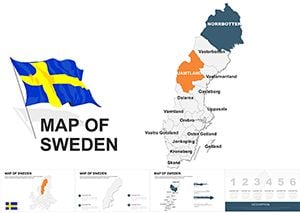
Experience the breadth of the planet through our large scale Keynote maps templates, engineered for high-impact geographic storytelling. From sweeping continental vistas to intricate oceanic patterns, these designs deliver precision on expansive canvases, ideal for unveiling international trends or project scopes.
Suited for analysts, consultants, and academics, they provide effortless scaling and layering to accommodate dense data without compromise. Key perks include vibrant yet professional aesthetics that hold attention during long sessions.
Integrate seamlessly into your Keynote workflow and elevate discussions with visuals that span horizons. Peruse our assortment and claim the template that charts your course.


Large scale Keynote maps transform ordinary slides into gateways for exploration, offering a panoramic lens on worldwide phenomena. They empower users to layer narratives atop geographic foundations, fostering deeper insights than fragmented visuals ever could.
Consultants deploy them for market entry analyses, while scientists map biodiversity hotspots - versatility defines their appeal.
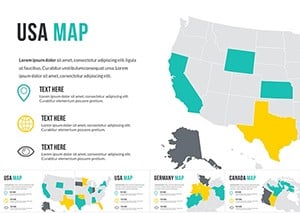
Visualize expansion strategies with flagged territories, highlighting opportunities and risks on a unified globe.
Lecturers illustrate tectonic shifts or migration patterns, using animations to simulate movement across scales.
Advocates chart impact areas, overlaying stats to rally support with compelling spatial arguments.
Versus Keynote`s built-in maps, which limit customization, these templates boast modular components for bespoke builds, ensuring every presentation feels tailored.
Anchor maps with consistent projections to avoid distortion, and employ subtle glows on key areas for emphasis. Sequence reveals via builds to pace information delivery effectively.
Incorporate 360-degree spins using Keynote`s rotate tool, or embed live web maps for current data pulls. This interactivity turns passive viewers into active explorers.
Pro insight: Pair with chart overlays for hybrid slides that merge location with metrics seamlessly.
Chart new territories effortlessly. Download large scale Keynote maps and bring the world to your slides.
Copyright © 2009-2026 ImagineLayout All rights reserved.