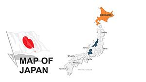
Navigate the archipelago with precision using our Japan map PowerPoint templates. Geared toward educators, analysts, and adventurers, these tools offer detailed outlines of all 47 prefectures, customizable for highlighting trade routes, tourist hotspots, or demographic trends.
Whether mapping earthquake impacts for disaster preparedness or plotting sales territories for export firms, our templates turn complex data into clear, engaging visuals. Features include layered vectors for easy edits, color-coded legends, and animation paths that trace historical migrations or bullet train lines.
Built for accuracy and aesthetics, they draw from official geographic data while incorporating stylistic flourishes like subtle elevation shading. Effortlessly integrate with your slides for presentations that inform and intrigue.
Chart your course today: Peruse our Japan map collection and download the ideal template for your project.

Maps are storytelling devices, and our Japan PowerPoint map templates excel at narrating spatial narratives. They surpass standard clipart by providing scalable, high-fidelity renders that withstand zooming - ideal for large-screen displays. Add pins for events like the Gion Festival or heat maps for population density, all without distorting shapes.
Professionals in logistics use them to optimize shipping lanes across Honshu and Kyushu, while historians overlay timelines of shogun eras. The result? Audiences grasp concepts faster, retaining 65% more information through visual aids.
In contrast to free online generators, which often produce low-res exports, ours ensure print-ready quality every time.
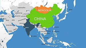
From educational modules dissecting tectonic plates to corporate strategies evaluating market penetration in Hokkaido versus Okinawa, versatility defines these templates. Tourism boards craft route planners with waypoint animations, guiding virtual explorers through the Inland Sea.
These techniques make abstract ideas tangible, fostering informed discussions.
Begin with purpose: select projections like Mercator for global contexts or azimuthal for polar emphases. Limit colors to five for clarity, using harmonious schemes inspired by Japanese ink washes. Include scale bars and north arrows consistently, and narrate paths verbally to guide eyes.
For interactivity, hyperlink regions to detail slides - clicking Tokyo reveals subway infographics. Validate data sources on-screen to build credibility.
Map your success: Secure a template download and transform data into destinations.
In an interconnected world, Japan map templates bridge distances, making the familiar feel exploratory. They`re tools for discovery, turning slides into journeys.
Embark immediately - download now!
Every one of the 47 prefectures is vector-based, allowing individual highlighting or grouping without quality loss.
Yes, import Excel data for automatic coloring based on values like rainfall or tourism stats.
Comprehensive coverage extends to all major islands and remote territories for full geographic scope.
Path animations trace routes, while fade-ins reveal layers sequentially for controlled information flow.
Vector format ensures crisp prints up to poster size, perfect for conference handouts.
Copyright © 2009-2026 ImagineLayout All rights reserved.