Harness the power of Apple ecosystem with our Japan map Keynote templates, meticulously designed for seamless integration on Mac, iPad, and iPhone. Aimed at creative professionals, teachers, and strategists, these maps detail prefectures, cities, and topographical features with effortless editing capabilities.
Perfect for illustrating supply chains in tech firms or guiding virtual field trips through Nara`s ancient sites, our templates leverage Keynote`s native tools like Magic Move for fluid transitions between zoomed views. High-contrast outlines and thematic fills make data pop, whether charting climate zones or cultural distributions.
With a focus on intuitiveness, each template includes pre-set builds and inspector-friendly layers, ensuring your workflow stays uninterrupted. Elevate your Apple presentations with geographic precision that feels as natural as a haiku.
Map out brilliance: Check out our Keynote Japan maps and download to start innovating.
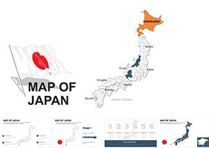
Keynote`s elegance pairs perfectly with our Japan map templates, offering buttery-smooth animations that rival professional cartography software. Forget clunky imports - these are native .key files, optimized for iCloud sync and multi-device editing. Zoom into Shikoku`s rugged coasts or pan across the Sea of Japan without lag, thanks to lightweight vectors.
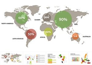
Designers praise the color-matching tools for aligning with brand guidelines, while analysts embed live data from Numbers for real-time updates. This integration turns static maps into living documents, enhancing collaboration in creative agencies.
Outperforming generic downloads, these templates exploit Keynote`s strengths for superior visual storytelling.
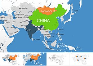
Leverage for app development pitches mapping user demographics in Osaka or environmental reports on Fukushima recovery. Art directors storyboard film locations with overlaid annotations, using Keynote`s drawing tools for custom paths.
Innovations like these make presentations interactive masterpieces.
Utilize the Format sidebar for precise adjustments - tweak stroke weights to evoke brushstrokes. Group elements for bulk manipulations, and use master slides for consistent legends. Test on multiple Apple devices to ensure responsive scaling.
Incorporate accessibility features like alt text for regions, promoting inclusive viewing. For flair, sync with GarageBand for ambient koto soundtracks during map reveals.
Unlock Apple potential: Download your Japan Keynote map and elevate your craft.
These templates embody Japan`s meticulous spirit within Keynote`s intuitive frame, inspiring precision in every projection.
Download and design - your maps await!
Fully optimized for iPad Keynote, with touch-friendly controls for on-the-go edits.
Select the shape, go to the Hyperlink inspector, and link to URLs or internal slides seamlessly.
Yes, copy-paste tables directly, and Keynote auto-formats them into map-compatible charts.
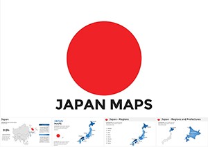
Included elevation contours and bathymetric details for comprehensive terrain views.
All templates save automatically to iCloud, enabling instant access across your Apple devices.
Copyright © 2009-2026 ImagineLayout All rights reserved.