Navigate the pulse of modern metropolises through our dynamic PowerPoint templates focused on megapolises. Geared toward urban planners, architects, and real estate professionals, these designs capture the scale and vibrancy of sprawling cities like Tokyo or New York with layered city grids and population heatmaps.
From infrastructure overviews to sustainability challenges, the templates facilitate discussions on smart city tech and demographic shifts. Built-in animations reveal growth trajectories, while color-coded districts highlight zoning variances.
Advantages encompass drag-and-drop skyline silhouettes, integration with GIS data for accurate mapping, and versatile aspect ratios for conference halls. These assets transform routine reports into immersive journeys through urban evolution.
Scan our assortment and construct presentations that blueprint the future of city living.
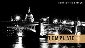
Megapolises represent hubs of opportunity and complexity, where presentations must balance grandeur with granularity. Our templates deliver with panoramic backgrounds of high-rises fading into subway networks, ideal for dissecting commuter patterns or green space allocations.
Stakeholders from municipal governments to corporate developers leverage these for pitches on high-speed rail or vertical farming initiatives, with slides that scale from neighborhood vignettes to metropolitan overviews.
Outpacing generic urban themes, ours feature authentic architectural motifs and demographic icons, minimizing sourcing efforts.
Highlights include pivot table compatibilities for real-time demographic tweaks and thematic transitions mimicking dawn-to-dusk cycles. Pro tips: Open with aerial views to set scale, then zoom into pain points like traffic congestion with targeted infographics.
Ensure narrative flow by threading a "before urban sprawl, after smart interventions" motif throughout.
Envision a deck for a megacity transit proposal: Initial slides orbit satellite imagery, building to cross-sections of proposed maglev lines with cost-benefit tables. For cultural heritage talks, interweave historical timelines with modern overlays, illustrating preservation amid progress.
In educational modules, simulate population booms via growing city models, engaging students in what-if scenarios.
Incorporate collaborative features like shared hyperlinks to 3D models, turning solo efforts into team symphonies. Mitigate info dumps by employing progressive disclosure, unveiling layers only as context builds.
Urban density challenges are met with modular grids that rearrange for focus on housing or commerce districts.
Conventional slides often feel flat; our depth-layered compositions evoke the verticality of megapolises, complete with shadow effects for building facades and light pulses for nightlife vibes.
Acquire your template and skyline your strategies with metropolitan mastery.
Build bridges to brilliant urban narratives - download your megapolises template today.
Copyright © 2009-2026 ImagineLayout All rights reserved.