 Click to zoom
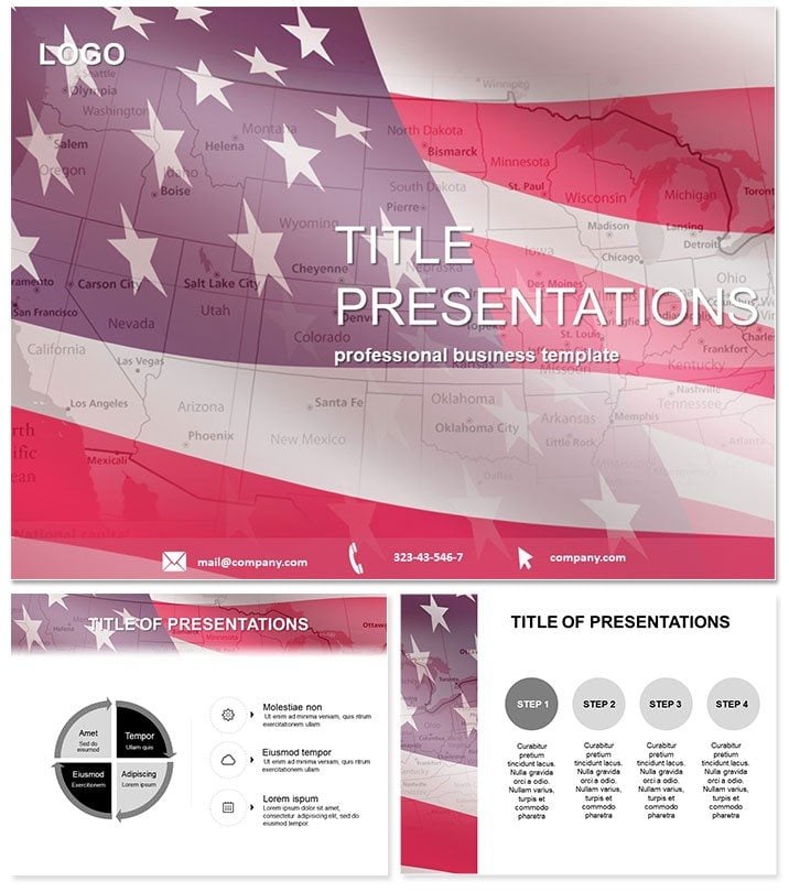
US States Flags PowerPoint Template: Map Out Patriotism
| Format | .pptx |
| Slides | 3 unique layouts |
| Aspect ratio | 16:9 |
| Compatibility | PowerPoint |
| Animated | No |
| Language | English |
| License | Commercial |
| File size | — |
| Version | v1.0 |
| Last updated | January 2025 |
What's inside
Evoke the spirit of unity and diversity across America`s heartland with visuals that blend state flags atop detailed maps, making every presentation a journey through the nation`s fabric. The US States Flags PowerPoint Template is ideal for historians, policymakers, and marketers aiming to contextualize regional influences with striking, memorable designs.
This tool transforms dry facts into engaging tapestries, whether debating federal policies or celebrating cultural milestones, ensuring your slides foster connection and insight in equal measure.
Features That Flag Excellence
Featuring 28 map-infused diagrams in seven patriotic color schemes - from star-spangled blues to earthy tones - this template honors variety. Three masters set a cohesive tone, backed by three backgrounds evoking landscapes from coasts to plains.
- Interactive Map Layers: Peel-back effects revealing state details.
- Flag Integrations: Accurate heraldry with editable emblems.
- Geospatial Icons: Capitals, borders, and routes pre-placed.
- Ratio Options: 16:9, 4:3, and 16:10 for all venues.
Works with PowerPoint 2016+, across OS. $22 one-time buys forever flags of quality.
Navigating the 28 Slides: State by State
Slide 1 overviews the continental map with all 50 flags pinned. Slides 2-10 regionalize: Northeast clusters with historical notes on liberty bells. Midwest focus in 11-15: Corn belts and industrial icons via overlaid flags.
South and West in 16-25: Civil War sites and gold rush trails animated. Slides 26-28 compare electoral impacts, with heatmaps under union jack motifs. Precision mapping ensures geographical fidelity.
Applications: From Classroom to Capitol
Teachers illustrating the Electoral College use Slide 28`s heatmap to spark civics debates. Lobbyists in DC adapt regional slides for policy pitches, highlighting state-specific stakes. Marketers targeting regions leverage flag visuals for localized campaigns.
Beats plain PowerPoint maps with thematic depth, cutting research time dramatically.
Wave your message high. Download the US States Flags Template today for presentations that stand tall.
Why It Outshines Standard Maps
Default inserts lack narrative punch; this infuses history and symbolism, vetted by geographers. Collaborative edits via shared links keep teams aligned on updates.
Trusted in educational and governmental circles, it builds narratives that endure.
Frequently Asked Questions
Are maps vector-based?
Yes, for crisp zooms and prints.
Editable flags?
Fully, swap colors or add text overlays.
US territories included?
Core 50 states; add-ons available.
Animation support?
Subtle fades for regional reveals.
Global use license?
Lifetime, worldwide okay.
Quick setup?
Plug in data in under 15 minutes.
Good for
- Project roadmaps and sprint plans
- Product launch timelines
- Quarterly or annual review decks
- Company history and milestone summaries
Licence
reviews
Created a political campaign strategy map, the state flag pins on the electoral heatmaps helped us focus the advertising budget.
The star-spangled blues to earthy tones are very patriotic, but the 'US states' theme is so specific that it is useless for any international project.
The peel-back effects revealing state details and the regional clusters with historical notes helped the students learn the geography.
I used it for a logistics company report, the geospatial icons for capitals and routes helped us optimize the delivery zones.
It is a great template for US-focused presentations, the 28 map diagrams are detailed, but the heavy 'flag' motif is a bit overkill for a simple logistics map.
FAQ
Will it work in Google Slides?
Are fonts embedded?
Can I use this for client work?
What's the refund policy?
Do you update the template after purchase?
Similar templates
See all PowerPoint Templates →
All 1 slides