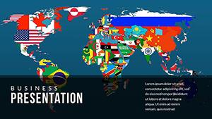
Bring the world to your slides with our geography maps PowerPoint templates, meticulously designed for educators, travelers, and analysts. These templates feature high-fidelity, editable maps - from global projections to detailed country outlines - empowering you to layer data like population densities or trade routes with ease.
Suitable for lecture halls or boardrooms, they include legend tools, scale bars, and color gradients to convey spatial stories compellingly. Whether illustrating migration flows or environmental changes, the vector-based designs ensure scalability without pixelation, maintaining sharpness across devices.
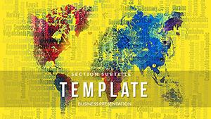
Aesthetic choices range from minimalist line art to vibrant topographical shades, all fostering audience immersion. Quick to customize, they let you focus on narrative over navigation.
Chart your course - peruse this category and download the map template that fits your vision.
Maps are the heartbeat of geography, and our PowerPoint templates amplify their role across professional and academic spheres. Geopolitics experts deploy them for briefings on border dynamics, overlaying conflict zones with timeline markers for chronological clarity. Travel agencies craft itinerary decks, pinpointing attractions with photo callouts on regional maps.
In schools, these templates aid lessons on physical features, with students annotating river basins collaboratively. Business strategists visualize supply chains, tracing commodity paths from origin to market via animated routes.
These scenarios harness maps` innate power to spatialize information memorably.
Built-in PowerPoint shapes or free clipart pale against our specialized templates, which offer pre-calibrated projections like Mercator for accurate area representations, avoiding distortions common in hasty inserts. Defaults demand manual legend creation, whereas ours auto-generate with data inputs, slashing prep time.
Enhanced with thematic shading algorithms, they reveal patterns - like urban heat islands - in ways static images can`t, boosting analytical depth. Professionals cite superior export quality for reports, with crisp lines retaining fidelity in grayscale prints.
Layer judiciously: base maps first, then data overlays with opacity tweaks for readability. Animate paths to narrate journeys, such as trade winds, syncing with voiceovers for rhythm.
Creatively, integrate 360-degree embeds for virtual flyovers of landmarks, transforming static slides into experiential hubs.
Documentary filmmaker Nora mapped indigenous territories in her pitch, securing funding through evocative overlays. Geography teacher Ben`s ocean current templates engaged remote classes, inspiring a student-led currents project. A logistics firm used route optimization decks to cut delivery times by 15%, crediting visual clarity.
These wins showcase maps` storytelling prowess via our designs.
Navigate to excellence - choose and download your map template now.
Navigating queries on our geography maps PowerPoint templates.
More insights? We`re here to guide.
Plot your next big idea - download today!
Copyright © 2009-2026 ImagineLayout All rights reserved.