 Click to zoom
"Ignite Awareness, Not Flames: Mastering Bushfire Narratives"
| Format | .pptx |
| Slides | 3 unique layouts |
| Aspect ratio | 16:9 |
| Compatibility | PowerPoint |
| Animated | No |
| Language | English |
| License | Commercial |
| File size | — |
| Version | v1.0 |
| Last updated | October 2022 |
What's inside
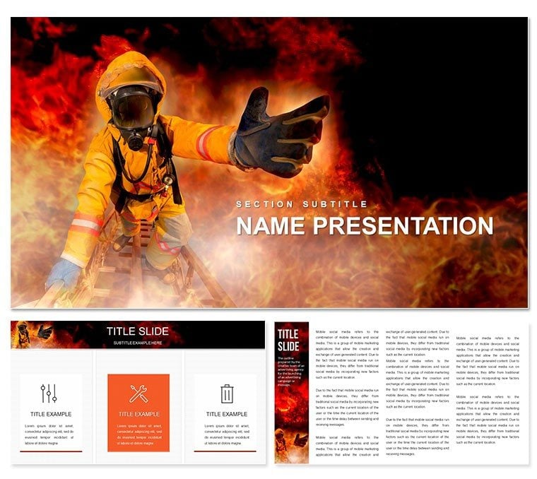
Bushfires and wildfires don't just scorch landscapes - they test our preparedness, demanding presentations that cut through smoke to deliver life-saving insights. The Bushfire and Wildfire Risks PowerPoint template rises to this challenge with 28 targeted diagrams in seven color schemes, empowering safety trainers, environmentalists, and emergency responders to convey prevention with unflinching clarity. It's a beacon in the haze, turning hazard data into actionable wisdom.
Crafted for those stewarding community resilience - from rural firefighters to urban planners - this template operates fluidly in PowerPoint 2016+, with Google Slides for field-ready shares. Fiery yet controlled motifs - flame outlines framing risk zones - evoke urgency without alarmism, akin to briefing decks from agencies like Australia's Rural Fire Service. Whether mapping fuel loads or response chains, it equips you to foster vigilance.
In an era of escalating climates, why risk foggy forecasts when precision burns bright? This resource fans the flames of understanding. Venture in and harness its heat.
Flame-Proof Features: Diagrams Forged for Impact
Three master frameworks temper your tale: hazard horizons for scopes, tactical terrains for tactics, and recovery radars for reflections. Three backgrounds temper intensity - smoky veils or ember scatters - grounding without gloom.
28 diagrams fuel the fire: Slide 4's contour map gradients fuel density, tunable for regional variances. Slide 19 chains command hierarchies in a blaze flowchart, modular for drill adaptations. Vectors endure scrutiny, from projectors to pamphlets.
Seven color schemes kindle context: scorched oranges for threats, cooling azures for mitigations, flicked to suit seasonal alerts.
- Hazard Hotspots: Heat maps for ignition probabilities.
- Prevention Protocols: Step ladders for clearance routines.
- Response Relays: Relay icons for crew coordinations.
Fanning Efficiency in Your Preparedness Playbook
Sparking use is elemental: Fire up the .pptx, zero on slide 7's ember trajectory, infuse wind data for arcs. Sequence bursts for drama, disseminate via emergency apps for instant drills.
This kindles protocols like incident commands, where visuals blaze trails. A responder retooled one for hazard hunts, scorching complacency in volunteer ranks.
Scorching Scenarios: Training, Talks, and Turnouts
Running a community workshop? Blaze from slide 2's overview inferno to slide 16's buffer blueprint - zones radiating from structures. This radial reveal mirrors spread models, kindling participation.
For policy pushes, slide 25's consequence cascade links losses to lags, with editable links for advocacy. Outflames generics by igniting locale cues, sharpening stakes.
- Safety Sessions: Branch burn plans for homestead defenses.
- Incident Insights: Timeline torches for after-action learns.
- Evac Drills: Path pyres guiding escape vectors.
Ecologists wield these for restoration rallies, where risk renders rally cries.
Quelling Common Conflagration Comms
Presentations often smolder in obscurity; contour cradles like slide 10 encase evacs, illuminating lanes. Bests blanks with tempered transitions, plus phased flares for focus.
Tag terrain layers for terrain teams, fitting field foes. For reach, raster rasters for remote views.
Blazing Best Practices for Enduring Embers
Frame as a fire saga: Hazards as hearths, heroes as handlers. Trim to triad visuals per pane to sustain spark, aping alert's acuity. Chronicle changes in char notes for chronicle keeps.
More than munitions, this template torches inertia. As a warden worded, it wildfires worries away. Snatch it to sear safety into souls.
Frequently Asked Questions
What risks does the template address?
Bushfire ignition, spread, and consequences, plus firefighter tactics.
Editable for local contexts?
Fully - maps and metrics mold to your terrain and threats.
Google Slides friendly?
Yes, for on-the-go shares in response networks.
Ideal for training modules?
Precisely, with flows for drills and debriefs.
Color role in risk relay?
Alerts escalate from yellow warnings to red urgents.
Good for
- Project roadmaps and sprint plans
- Product launch timelines
- Quarterly or annual review decks
- Company history and milestone summaries
Licence
reviews
Used the contour map for fuel density gradients in a fire safety seminar, the tunable regional variances were accurate.
The blaze flowchart for command hierarchies was useful, but the heat maps for ignition probabilities were too pixelated.
Just needed a quick visual for an evac drill handout, the flame outlines framing risk zones were striking.
The ember trajectory infuse with wind data was a lifesaver for the incident response simulation, the phased flares for focus worked well.
Okay for an emergency services briefing, but the scorched oranges scheme made everyone feel hot.
FAQ
Will it work in Google Slides?
Are fonts embedded?
Can I use this for client work?
What's the refund policy?
Do you update the template after purchase?
Similar templates
See all PowerPoint Templates →


All 1 slides