Keynote Maps of Newfoundland and Labrador in Canada | Presentation Download

#0
#1
#2
#3
#4
#5
#6
#7
#8
#9
#10
#11
  • thumbnail slide #0
  • thumbnail slide #1
  • thumbnail slide #2
  • thumbnail slide #3
  • thumbnail slide #4
  • thumbnail slide #5
  • thumbnail slide #6
  • thumbnail slide #7
  • thumbnail slide #8
  • thumbnail slide #9
  • thumbnail slide #10
  • thumbnail slide #11

Type: Keynote Maps template

Category: North America

Sources Available: .key

Product ID: KM00128

Template incl.: 12 editable slides

Purchase this template
$ 10.00

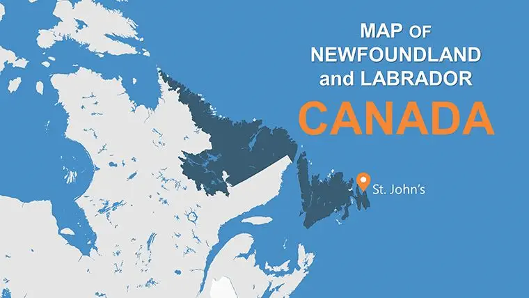
Newfoundland and Labrador, Canada's easternmost province, is known for its rugged coastline, rich history, and unique culture. From picturesque fishing villages to ancient Viking settlements, there's no shortage of things to explore in this beautiful region. But, to make the most of your visit, you need a reliable guide, and that's where Keynote Maps of Newfoundland and Labrador come in.

In this article, we'll take an in-depth look at Keynote Maps of Newfoundland and Labrador and explore what makes them so unique. We'll also provide you with a comprehensive guide on how to use these maps to plan your visit to this beautiful province. Whether you're a first-time visitor or a seasoned traveler, this guide will provide you with all the information you need to make the most of your time in Newfoundland and Labrador.

What are Keynote Maps of Newfoundland and Labrador?

Keynote Maps of Newfoundland and Labrador are detailed and comprehensive maps that cover the entire province. These maps are available in both paper and digital formats and are designed to help visitors navigate the region and plan their itinerary.

These maps are created by a team of experts who have extensive knowledge of the region. They include detailed information on attractions, accommodations, restaurants, and other points of interest. In addition, the maps are designed to be easy to read and include clear and concise information.

How to Use Keynote Maps of Newfoundland and Labrador

Using Keynote Maps of Newfoundland and Labrador is easy. Here's a step-by-step guide on how to use these maps to plan your trip:

  1. Start by identifying the areas you want to visit: Newfoundland and Labrador is a vast province with many different regions to explore. Decide which areas you want to visit and make a list of the attractions and points of interest you want to see.
  2. Get a copy of Keynote Maps of Newfoundland and Labrador: You can purchase these maps online or at various tourist centers throughout the province. These maps are available in both paper and digital formats.
  3. Study the maps:Take the time to study the maps and familiarize yourself with the different regions and attractions. Use the maps to plan your route and decide which areas you want to visit first.
  4. Use the information on the maps: Keynote Maps of Newfoundland and Labrador include detailed information on attractions, accommodations, restaurants, and other points of interest. Use this information to plan you're itinerary and make reservations.
  5. Take the maps with you: Whether you're exploring the province by car, bike, or on foot, be sure to take your Keynote Maps of Newfoundland and Labrador with you. These maps are an essential tool for navigating the region and ensuring you don't miss any must-see attractions.

What Makes Keynote Maps of Newfoundland and Labrador Unique?

There are many different maps available for exploring Newfoundland and Labrador, but Keynote Maps stand out for several reasons:

  1. They are comprehensive: Keynote Maps of Newfoundland and Labrador cover the entire province, including both the island and mainland. They include detailed information on attractions, accommodations, restaurants, and other points of interest.
  2. They are easy to read: Keynote Maps are designed to be easy to read and understand. They include clear and concise information and are updated regularly to ensure accuracy.
  3. They are created by experts: The team behind Keynote Maps of Newfoundland and Labrador includes experts in the region's history, culture, and geography. This expertise is reflected in the maps' accuracy and the information they provide.

They are available in both paper and digital formats: Whether you prefer a traditional paper map or a digital map that you can access on your smartphone or tablet, Keynote Maps of Newfoundland and Labrador have you covered.

Keynote Maps of Newfoundland and Labrador are an essential tool for anyone visiting this beautiful region of Canada. These comprehensive and easy-to-read maps are created by experts and provide visitors with all the information they need to plan they're itinerary and navigate the province's many attractions. Whether you're a first-time visitor or a seasoned traveler, be sure to pick up a copy of Keynote Maps of Newfoundland and Labrador to ensure you don't miss any must-see sights on your trip.

Alberta Canada Keynote maps
ID: #KM00091
Alberta Canada Keynote maps
Canada Provinces Keynote maps
ID: #KM00096
Canada Provinces Keynote maps
Nova Scotia Canada Keynote maps
ID: #KM00132
Nova Scotia Canada Keynote maps
Map of Prince Edward Island Canada Keynote maps
ID: #KM00139
Map of Prince Edward Island Canada Keynote maps
Canada British Columbia Keynote Maps Template Presentation Download
ID: #KM00094
Canada British Columbia Keynote Maps Template Presentation Download
Saskatchewan Canada Keynote maps Templates
ID: #KM00143
Saskatchewan Canada Keynote maps Templates
Government of Canada Keynote Maps Template Presentation
ID: #KM00097
Government of Canada Keynote Maps Template Presentation
Canada maps: Keynote map of Manitoba template
ID: #KM00112
Canada maps: Keynote map of Manitoba template